Wyoming

Our Favorite Businesses
Follow Us
On Social


Cloud Peak Skyway Scenic Byway, Wyoming.
Cloud Peak Skyway Scenic Byway
Includes Buffalo Wyoming, Powder River Pass, Bighorn National Forest, Medicine Lodge State Archaeological Site, Ten Sleep Canyon, Ten Sleep Wyoming
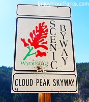 The Cloud Peak Skyway Scenic Byway is the located between the towns of Buffalo Wyoming and Ten Sleep Wyoming, and is a very scenic 47 mile stretch along U.S. Highway 16. This popular Wyoming scenic
byway involves the 9,666 foot Powder River Pass, which provides wonderful views but also is greatly affected by weather, where snow can fall on this section of the Cloud Peak Skyway Scenic Byway every month of the year without much warning. Named after the famous Cloud Peak, this 13,167 foot high mountain is located west of Buffalo in the heart of the Bighorn Mountains, and is the tallest peak in the range.
Among the most popular attractions along the Cloud Peak Skyway Scenic Byway include the historic town of Buffalo Wyoming, Powder River Pass, Medicine Lodge State Archaeological Site, Bighorn National Forest, Ten Sleep Canyon and the historic town of Ten Sleep Wyoming.
Buffalo, Wyoming
Located on the west end of the Cloud Peak Skyway Scenic Byway at the intersection of Interstate 25 and U.S. Highway 16, Buffalo Wyoming is a charming western town loaded with history that includes pioneers,
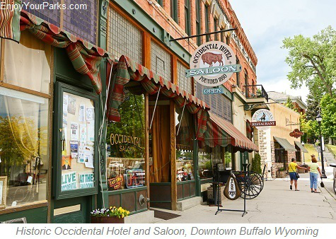 gold miners, outlaws, cowboys, Indians and soldiers. Founded in 1878, some legendary western characters walked its streets, such as Calamity Jane, Butch Cassidy and the Sundance Kid, Tom Horn, Buffalo Bill Cody, Owen Wister and Teddy Roosevelt.
Nestled beside the amazing Bighorn Mountains, Buffalo Wyoming has a charming main street that is "classic old west", and has several historic buildings througout the town.
And close by Buffalo Wyoming is Fort Phil Kearney State Historic Site to the north, the fabled "Hole In The Wall" used by Butch Cassidy and the Sundance Kid, and the TA Ranch- which is the home the final battle of the Johnson County Cattle Wars (1892) and Fort McKinney. All of these fascinating attractions are within a short driving distance from Buffalo. There are also many great restaurants, shops and lodging facilities in and around Buffalo for visitors to enjoy.
Bighorn National Forest
The Cloud Peak Skyway Scenic Byway skirts along the southern end of the 1.1 million acre Bighorn National Forest, which is home to not only the magnificent Bighorn Mountain Range, but also seemingly
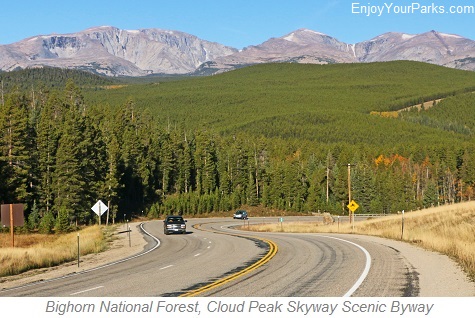 limitless outdoor recreation opportunities. There are over 1,500 miles of hiking trails in this massive forest, 32 improved campgrounds, and two additional byways that run through these mountains, which are the Bighorn Scenic Byway (which cuts through the middle of the Bighorn National Forest), and the Medicine Wheel Passage.
Within the confines of the Bighorn National Forest lies the 189,000 acre Cloud Peak Wilderness Area, which is home to the 13,167 foot high Cloud Peak, the tallest peak in the Bighorn Range.
The Bighorn National Forest is primarily made up of lodgepole pine, and there is a host of spectacular wildlife living in this thriving forest such as elk, black bear, pronghorn, deer, mountain lions, moose and more. There are also many lakes found throughout the forest that are naturally stocked with trout as well as many other species of fish.

Cloud Peak Skyway Scenic Byway in Northern Wyoming
Powder River Pass
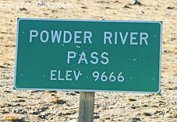 Just about midway between Buffalo and Ten Sleep Wyoming along the Cloud Peak Skyway Scenic Byway lies the Powder River Pass. This amazing pass takes visitors over the south end of the mighty Big Horn Mountains, and is 9,666 feet in elevation. This is a very scenic section of the Cloud Peak Skyway Scenic Byway of Wyoming, but with its high elevation snow storms can hit the area any month of the year....Including July and August! So always check the weather reports before heading out on the Cloud Peak Skyway Scenic Byway.
There are pullouts and overlooks throughout the Cloud Peak Skyway Scenic Byway of Wyoming, and we highly recommend that you take the time to stop at them and take in the view. And spend some time on Powder River Pass, as most people do not experience an elevation of 9,666 very often in their lives, especially if they don't spend a lot of time in the Rocky Mountains. And remember to bring a jacket, because you just never know what kind of weather or temperature you'll experience on this high mountain pass.

Cloud Peak Skyway Scenic Byway near Powder River Pass.
Sitting Bull Campground / Meadowlark Lake
The ever-popular Sitting Bull Campground is located approximately 23 miles northeast of Ten Sleep (40 miles from Buffalo), and rests just north of Meadowlark Lake along the Cloud Peak Skyway Scenic Byway. The elevation is about 8,600, so even in the summer you might expect nice, refreshing cool evenings. There are 42 campsites within 2 loops, where most are RV friendly... there are even some sites 70 feet in length, with the average being about 60 feet. The Sitting Bull Campground, which is a Bighorn National Forest Campground, is usually open from early June through mid-September, and provides drinking water and restrooms. There are no showers, electricity or phones. Meadowlark Lake is a popular lake for fishing and many other water sports, and there are several resorts, lodges and cabins surrounding this scenic mountain lake.


Ten Sleep Canyon
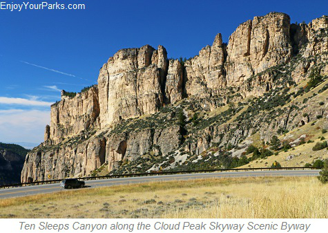
About 6 miles to the east of the little ranching town of Ten Sleep, you will drive through Ten Sleep Canyon of the Bighorn Mountain Range. Ten Sleep Canyon is well-known throughout the rock-climbing world for
its outstanding rock climbing opportunities.
There are over 800 bolted routes found throughout the stone walls of the canyon, and if you look closely, you just might see these talented rock climbers on these towering walls as they work their way to the top.
The "climbing vibe" of this area is a laid back, friendly one, and the incredibly comical and strange names of the routes reflect this light-hearted environment of climbers...such as "Aunt Jemima's Bisquick Thunderdome", "Stereosonic Keyboard of Death", and "Hell Yes I Want Cheesy Poofs", "Beer Bong", "Evil Cheese Wiener", "Bikini Girls with Machine Guns", "Mr. Poopy Pants", "Killer Karma", "Great White Behemoth", "Wyoming Flower Child", "Architects on Acid", "Stop Talkin' and Start Chalkin'", and "Captain Insano"... just to name of few. There are several camping areas within the Ten Sleep Canyon, as well as day use picnic areas.

Ten Sleep Canyon along the Cloud Peak Skyway Scenic Byway of Wyoming.

Ten Sleep Canyon along the Cloud Peak Skyway Scenic Byway of Wyoming.
Ten Sleep, Wyoming
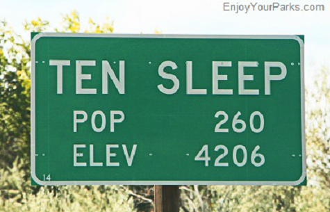
The town of Ten Sleep marks the eastern-most end of the Cloud Peak Skyway Scenic Byway, and is rich in western history. Ten Sleep Wyoming supposedly got its unique name from being a Native American "rest
stop", where it was 10 days (i.e. 10 "sleeps") from Fort Laramie to the southeast, 10 "sleeps" from Yellowstone National Park to the west-northwest, and 10 "sleeps" from the Indian Agency on the Stillwater River in Montana to the northwest.
Rich History
Ten Sleep Wyoming saw many historic events, such as the Spring Creed Raid of 1909, which was one of the last big confrontations between cattlemen and sheep ranchers known as the Sheep and Cattlemen's War. During this 1909 raid, cattlemen attacked sheep herders and their sheep, killing three herders and hundreds of sheep. In addition to cowboy history, there are many archaeological sites found throughout this historic area, where there continues to be new discoveries of Native American Artifacts such as arrowheads, petroglyphs and pictographs. Ten Sleep, with a population of about 250 people, really has not changed much for over a hundred years, and there are still many of the original family owned cattle ranches throughout the Ten Sleep Area. And as you walk the main street of Ten Sleep, you'll more than likely notice an odd combination of the folks living in harmony, such as cowboys, hippies, hunters and rock climbers. These odd bedfellows are found throughout this "small town with a really big heart".
North of Ten Sleep....
Medicine Lodge State Archaeological Site
Located along the western slope of the Bighorn Mountain Range north of the town of Ten Sleep, the Medicine Lodge State Archeological Site is a popular destination for visitors interested in observing
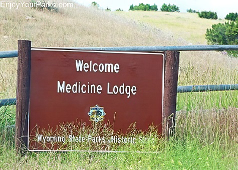 hundreds of Native American petroglyphs and pictographs. This remarkable area is regarded as one of Wyoming's premier archaeological sites that is very much worth your while during your Wyoming vacation... that is if you are interested in incredibly preserved Native American "rock art".
The Medicine Lodge State Archaeological Site is located on a large sandstone cliff that is home to literally hundreds of remarkably well-defined petroglyphs and pictographs...some dated back to 10,000 years. Known as "rock art", information about the fascinating history of the site is found at the Medicine Lodge State Archaeological Site Visitor Center and Library, which are found at the site. Located along the base of the 750 foot long cliff are interpretive signs that are also very helpful and interesting as you look at these remarkable Native American pictographs and petroglyphs.

Medicine Lodge State Archaeological Site of Wyoming.


Directions
To get to Medicine Lodge State Archeological Site, from Ten Sleep, take the Lower Norwood Road to Hyattville, and then follow the Cold Springs Road to County Road 52.
Campsites
In addition to the amazing pictographs and petroglyphs, there are 27 campsites with picnic tables and fire rings located at the Medicine Lodge State Archeological Site, which are conducive to RV or tent camping. There are also toilets and water hydrants (potable water) located thoughout these sites, and there is also a large reservation-only group area and shelter for large group events.

Medicine Lodge State Archaeological Site of Wyoming.
Share This Page On Social:
