Glacier Park

Our Favorite Businesses
Follow Us
On Social

Lee Ridge Trail

View of Mount Cleveland from Lee Ridge, Glacier National Park
Lee Ridge Trail
Trailhead: Mile 17.8 on the Chief Mountain Highway
(approximately 300 yards southeast of the Chief Mountain Customs Trailhead parking lot)
Distance: 6.0 miles (one way)
Elevation Gain: 1,600 vertical feet (approximately)
This pleasant Glacier National Park hike along the Lee Ridge Trail is very scenic and enjoyable. You will get great views of Chief Mountain, Gable Mountain and Mount Cleveland, the tallest mountain in Glacier National Park. The Lee Ridge Trail connects up with Gable Pass Trail at about mile 5.7, and approximately 0.3 miles to the west of this junction is the actual Gable Pass, where the trail then heads down 1000+ vertical feet to Slide Lake to the east. Back at the junction of Gable Pass Trail and Lee Ridge Trail, if you head west the trail will take you down into the Belly River Valley and eventually connect you with the Belly River Trail. The Lee Ridge Trail is not considered to be a maintained trail but it is extremely easy to follow (as of summer of 2012).
Finding the Trailhead
The Lee Ridge Trailhead in Glacier National Park can be a little tricky to find unless you know exactly where to go. The best way to find it for the first time is drive along the Chief Mountain Highway to the Chief Mountain Customs Trailhead parking lot. This large parking lot is located just before you reach the Canadian Border. From the parking lot, turn around and drive less than a quarter mile until you see a small pullout to the left (north). Park your car there. Then walk eastward along the south side of the road until you see the trailhead sign that's kind of hidden in the trees along the highway. This sign is only about a 150 yards or so from the pullout. This is where you will begin your Glacier Park hike on the Lee Ridge Trail.
Lee Ridge Trail Description:
The Lee Ridge Trail is truly a magical area, and is one of our favorite day hikes in Glacier Park. The views are very interesting and beautiful, and the geology is quite different than anywhere else in the park. There's just something about this area we really, really like...

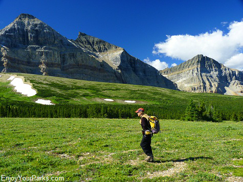
This is a view to the west, which includes Mount Cleveland, as Shannon works her way up the Lee Ridge Trail in Glacier National Park.
You will first hike through a pleasant lodgepole forest for about 3.5 miles, and it will then begin to open up into lush green open parks. It is there you will begin to get a great view of Chief Mountain, Ninaki Mountain and Papoose Mountain to the east. To the southwest you will briefly get a glimpse of Mount Merritt until Gable Mountain (to the south) blocks this view. To the west you will begin to enjoy a spectacular view of the great Mount Cleveland and surrounding area beyond the Belly River Valley.

This is a view to the east as you're hiking up the Lee Ridge Trail in Glacier National Park. This is a spectacular view of Chief Mountain, Ninaki Mountain and Papoose Mountain (from left to right).
 Gradually in the next mile the ridge really begins to open up into a gorgeous alpine meadow that makes you want to start singing "The Sound of Music" (we're not kidding). This is where you'll begin to understand why this is one of our favorite Glacier Park hikes. The view of Mount Cleveland to the west and Chief Mountain, Ninaki Mountain and Papoose Mountain to the east is remarkable, and Gable Mountain majestically looms directly in front of you to the south. At this point the trail becomes non-existent, and you then simply follow the cairns (piles of rocks) that are strategically placed about 50 yards apart for the rest of the hike as the trail climbs upward to the Gable Pass Trail junction.

View of Mount Cleveland from the Lee Ridge Trail in Glacier National Park. You can faintly see the Gable Pass Trail working its way down the green alpine slope before it drops into the Belly River Valley.
Gable Pass Trail Junction (mile 6.0)

Shannon standing at the Gable Pass Trail Junction. This marks the end of the Lee Ridge Trail.
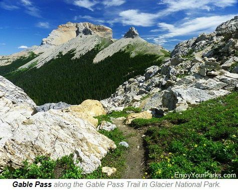
The Lee Ridge Trail ends at the Gable Pass Trail Junction, 6.0 miles from the Lee Ridge trailhead. From here, you can take a left and hike 0.4 miles to Gable Pass. Then if you'd like, you can continue on this trail as it works its way down the east side of Lee Ridge, dropping about 1,500 vertical feet in less than 1.7 miles to the north shore of Slide Lake near the Slide Lake Campground. If you take a right at the Gable Pass Trail Junction, the Gable Pass Trail will work it's way down the west slope of Lee Ridge and eventually end up near the Gable Creek Campground in the Belly River Valley in 2.3 miles.
If you want to simply make this a Glacier Park day hike, enjoy the hike along the Lee Ridge Trail, explore the Gable Pass Area, then head back up the Lee Ridge Trail to your car that's parked on the Chief Mountain Highway. Again, for some reason this is one of our favorite Glacier National Park hikes. Every time we hike this trail we thoroughly enjoy it. The scenery and views are wonderful, the alpine meadows are incredible, and the effort is always worthwhile.

Lee Ridge with Mount Cleveland, Glacier National Park.

Share This Page On Social:
