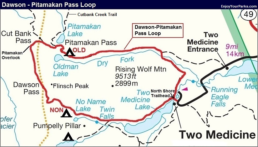
Dawson - Pitamakan Pass Loop
Multi-Day Hike Option

Dawson Pass, Glacier Park.
Trailhead: North Shore Trail at Two Medicine Campground
Distance: 19.0 miles
Elevation Gain: 2,939 feet
Elevation Loss: 2,939 feet
Maximum Elevation: 8,099 feet (Near Pitamakan Overlook)
Mountain Passes: Dawson Pass 7,603 feet, Pitamakan Pass (7,551 feet)
Backcountry Campgrounds: No Name Lake (NON), Old Man Lake (OLD)
Overview
The Dawson-Pitamakan Pass Loop is one of the best day hikes in Glacier National Park, and that is what most hikers use this remarkable trail for. However, some visitors want to turn this into a two night three day multi-day hike, so we’ll feature it here. We personally love hiking this loop in a single long day, but to each their own. The trail actually loops around Flinsch Peak and Rising Wolf Mountain, both of which are extremely photogenic. Flinsch Peak is a famous horn, being carved by three glaciers, and Rising Wolf Mountain is a massive mountain and the tallest in the Two Medicine Area. The scenery the entire hike is remarkable, especially once you reach Dawson Pass and the Continental Divide as you look down into the Nyack Area.
At Dawson Pass, to the south you will get a rare view of Mount St. Nicholas, as well as Mount Phillips that towers directly to the west just beyond a deep valley. The three mile hike to the Pitamakan Overlook along the Divide is world-class, which views that will stick with you for a lifetime. The trail reaches a high point of 8,100 feet above sea level, just beyond one of the most scenic overlooks in Glacier Park, known as Pitamakan Overlook. From this overlook, You enjoy tremendous views of Mount Phillips, Mount Stimson (one of the tallest peaks in the park), Mount Pinchot and Mount Logan. The trail then descends down to Pitamakan Pass, with Rising Wolf Mountain and Flinsch Peak dominating the view to the south.
The trail then further descends into a great cirque below Flinsch Peak where Old Man Lake rests. The view of Flinsch Peak from the shore of Old Man Lake is fantastic. Once hikers stay night #2 at Old Man Lake, the trail will then take them down the Dry Fork Creek Valley just below Rising Wolf Mountain to the south, and finally ends at the same exact spot you started at the North Shore Trailhead at Two Medicine Campground.
DAWSON - PITAMAKAN PASS LOOP DESCRIPTION
(MULTI-DAY OPTION)
North Shore Trailhead (mile 0.0)
The North Shore Trailhead is located at the Two Medicine Campground. A well built foot bridge will take you over across the inlet to Pray Lake, where the trailhead is just beyond the other side of the bridge. Go left, onto the North Shore Trail as it loosely follows the north shore of Two Medicine Lake for over three miles. Periodically you will enjoy great views of the mountains surrounding Two Medicine Lake, such as Sinopah Mountain, Painted Teepee and Grizzly Mountain. Rising Wolf Mountain towers over you to the north (right) the entire way.
NOTE: If you want to cut about 3 miles from your hike, you can take the Two Medicine Boat Tour to the far shore of Two Medicine Lake.
Trail Junction To South Shore Trail (mile 3.3)
3.3 miles from the North Shore Trail you will encounter the trail junction to the South Shore Trail, Boat Dock and Upper Two Medicine Lake. Stay right to keep heading toward Dawson Pass. As you continue to head west, Sinopah Mountain seems to rise higher and higher to the southwest, and the sharply pointed Pumpelly Pillar will begin dominating the view straight ahead of you to the west. The trail will work its way to the north of Pumpelly Pillar, with Mount Helen rising above Pumpelly Pillar to the west. In fact, Pumpelly Pillar is the east buttress of Mount Helen. The trail will now begin the brutal upward climb to Dawson Pass, where you will climb nearly 2,750 vertical feet in 3.6 miles!
No Name Lake Spur Trail Junction (mile 4.8)
At mile 4.8, you will find the No Name Lake Spur Trail Junction. The lake is 0.2 miles south of this junction, where it lies directly below the sheer north cliffs of Pumpelly Pillar. Some hikers like to spend the night at this small lake before heading for Dawson Pass the following morning. The trail is mainly in a mature forest, with open parks providing good views of the mountains.
No Name Lake Campground (NON), mile 5.0
No Name Lake Campground (NON) rests on the east shore of the lake, surrounded by trees. The entire south shore is at the base of the magnificent north face cliffs of Pumpelly Pillar.
Dawson Pass (mile 6.9, counting the extra 0.4 miles hiking to/from No Name Lake)
From No Name Lake, the trail continues its steep climb up to Dawson Pass. This is the least fun portion of the entire hike as you will wish at this point you had a lighter pack on your back. As the trail works its way up, Mount Helen will begin dominating the view to the southwest, and Flinsh Peak to the northwest. Because of the angle, Flinsch Peak will not seem to be a very dramatic horn, but once you get to the pass, its remarkably pointed summit will show itself. As you look down the valley, you’ll get a great view of Two Medicine Lake with Rising Wolf Mountain towering over it to the north. Sinopah Mountain will begin to show itself above Pumpelly Pillar as you gain in elevation.
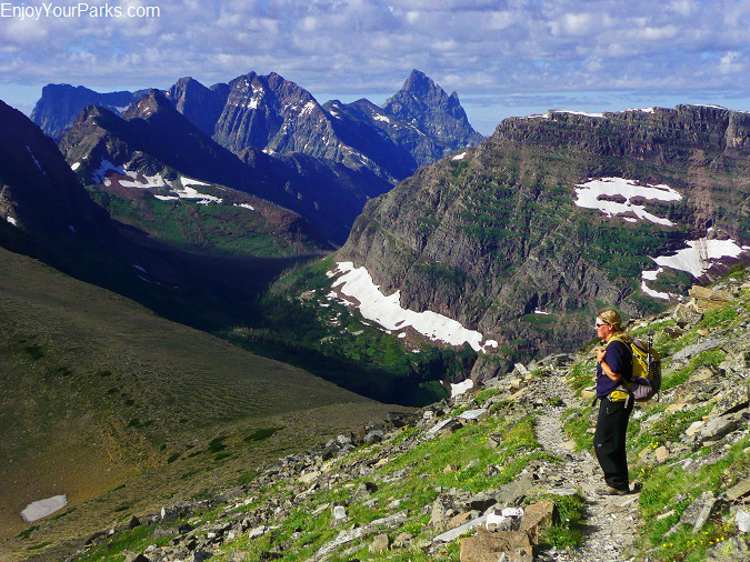
Once you reach Dawson Pass, the view to the west will take your breath away as the sharp spire of Mount Saint Nicholas dominates the view to the southwest, Mount Phillips and Lupfer Glacier to the straight west, and Mount Stimson towers to the northwest. All of these mountains are separated from you by a magnificent valley that is part of the Nyack Creek – Coal Creek Area. And of course the view looking back into the Two Medicine Valley is remarkable as well. The sharp horn of Flinsch Peak will be towering directly over you to the northeast as the trail works it’s way up the south buttress of Flinsch.
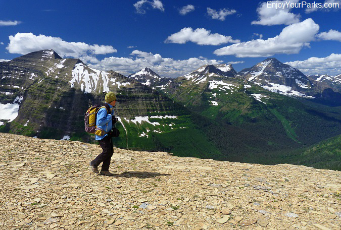
The trail will then climb another 500 feet directly below Flinsch Peak until it levels off onto the Continental Divide, where the view of Mount Stimson, Mount Pinchot, and Mount Phillips will knock your socks off. This next three mile stretch is one of the most scenic hikes in Glacier Park. (Sadly the valley below you had a destructive forest fire in recent years, so it will not be as scenic as before the fire. However, the views are still incredibly gorgeous. Pumpelly Glacier, which you will easily see far to the north as it rests on the south face of Blackfoot Mountain, really catches your attention as you hike northward along the Continental Divide. In time, you will also enjoy a very dramatic view of Old Man Lake far below you to the east as you hike along the nearly level trail through some of the most stunning landscapes you’ll ever see.
Pitamakan Overlook (approximately mile 9.2)
As the trail begins to wrap around Mount Morgan and starts heading north west, you will see a narrow buttress of rock heading straight west of the trail. Hike on top of this buttress just about a hundred yards to reach the end of it, which marks the Pitamakan Overlook. Straight to the west is one of the best views in Glacier Park as Mount Pinchot and Mount Stimson rise to the heavens across an amazingly deep valley of the Nyack. Even if you’re tired, we highly recommend standing at this spot as it just might change your life.
High Point at 8,099 feet (mile 9.7)
About a half mile beyond the Pitamakan Overlook, as the trail heads straight west along the north slope of Mount Morgan, you will reach the highest point along the Dawson-Pitamakan Pass Loop at 8,099 feet above sea level. At this point you will be able to look down at Pitamakan Pass and Pitamakan Lake, with Rising Wolf Mountain and Flinsch Peak dominating the view to the south. This is a great place to have lunch and take in the remarkable views in nearly all directions.
Cutbank Pass Trail Junction, mile 10.1
At mile 10.1, just below the high point of the trail, you’ll reach the Cutbank Pass Trail Junction, where if you go left you’ll hike over Cutbank Pass and drop into the Nyack. Stay right however to remain heading toward Pitamakan Pass and Old Man Lake. The trail descends down an open high alpine broad basin with no trees, only tundra.
Pitamakan Pass and Cutbank Creek Trail Junction (mile 10.3)
From the high point, the trail will descend through this open tundra basin about 500 vertical feet. At this point it will level off as you hike directly above Pitamakan Lake to the north, which is a dramatic view and very enjoyable. Pitamakan Pass is at the end of this narrow hike along the south cliff of Pitamakan Lake. At this point you’ll encounter the Cutbank Creek Trail Junction, which takes hikers down to Pitamakan Lake, then onto Morning Star Lake and eventually either Cutbank Ranger Station or Triple Divide Pass. Stay right to make the steep descent down to Old Man Lake at the base of Flinsch Peak, which is 500 vertical feet below Pitamakan Pass.
Old Man Lake (mile 12.2)
Two miles and 500 vertical feet below Pitmakan Pass you’ll reach Old Man Lake that rests in a large cirque at the base of Flinsch Peak. The view of Flinsch Peak from the east shore is dramatic, as the sharp horn really shows itself from this angle.
Old Man Lake Campground (OLD), mile 13.1
About a mile beyond the lake, you’ll reach Old Man Lake Campground as the trail drops down into Dry Fork Creek Valley. Rising Wolf Mountain towers over you to the south as you set up camp for the night. The trail beyond Old Man Lake Campground continues to drop in elevation as it works its way down Dry Fork Creek Valley along the north base of Rising Wolf Mountain.
Dry Fork Trail Junction, mile 16.8
At mile 16.8 you will reach the Dry Fork Trail Junction, where you stay right to continue onward to Two Medicine Campground. At this point the trail annoyingly climbs a few hundred vertical feet before descending again as it wraps around the east end of Rising Wolf Mountain.
North Shore Trailhead at Two Medicine Campground, mile 19.0
At mile 19.0, your hike will reach the North Shore Trailhead at the Two Medicine Campground, where you started your hike a few days earlier. Again, the Dawson-Pitamakan Pass Loop is a fantastic, world class day hike that you can turn into an overnight hike if you prefer.


