Harrison Lake Trail
Includes Boundary Trail

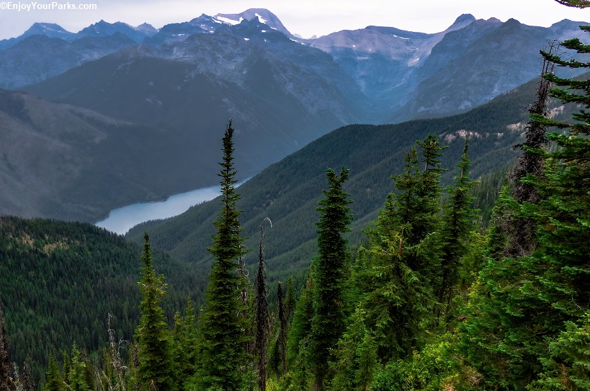
Harrison Lake as viewed from Loneman Mountain, Glacier National Park
Harrison Lake Trail
Includes Boundary Trail
Trailhead 1: West Glacier Montana
Distance: 10.0 miles (one way) from West Glacier Trailhead
Trailhead 2: Harrison Lake Crossing, Middle Fork Flathead River (U.S. Highway 2)
Distance: 2.9 miles (one way) from Harrison Lake Crossing (Middle Fork Flathead River)
Elevation Gain: 400 vertical feet
NOTE: More photos coming soon.
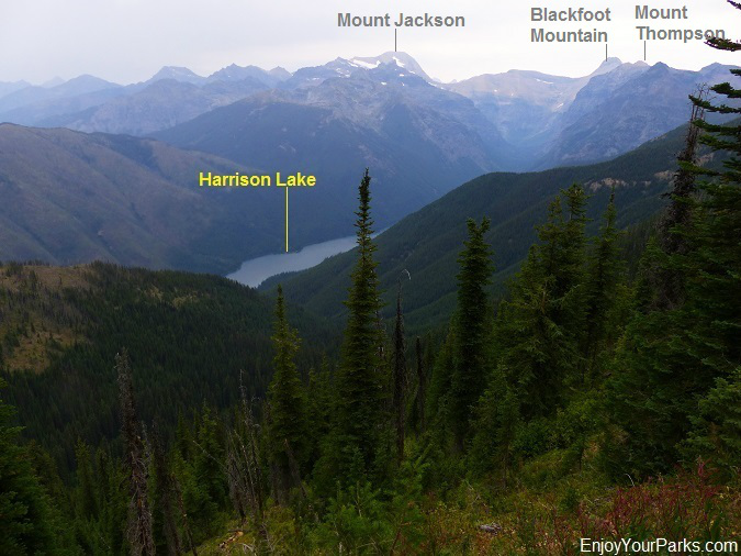
Harrison Lake in Glacier National Park is a rather large and seldom visited mountain lake along the southwest border of Glacier Park. Of the many Glacier Park Hikes, this is not on our list of "Favorite Glacier Park Hikes", but is still worth pursuing if you like exploring places that very few people ever see. Harrison Lake is nestled in a deep valley, and at the head of this deep valley towers the giants of Mount Jackson and Blackfoot Mountain. The massive Harrison Glacier that rests on the southeast face of Mount Jackson feeds this pristine mountain lake with cold glacier water. Midway up the north shore of Harrison Lake is Harrison Lake Campground, which is a designated back country campground for those of you who want to spend the night along the north shore of this secluded lake.
Finding The Trailhead(s)
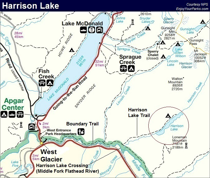
There are two ways to get to Harrison Lake in Glacier National Park. One way is to start at West Glacier Montana at the Boundary Trail trailhead (see map at bottom of page). The advantage of this trailhead is that you don't have to ford the Middle Fork of the Flathead River, which can be a little tricky until late August. The other option is the Harrison Lake Crossing, which dramatically shortens the hike to Harrison Lake in Glacier National Park but requires that you ford the Middle Fork Flathead River.
West Glacier /Boundary Trail Trailhead
At West Glacier Montana, you will see a paved road heading east just before you cross the Middle Fork Flathead River on the main highway as you are driving north towards the West Entrance. Take this road. In less than a half mile, you will reach a dead-end, and a large cement bridge that only allows foot travel. Walk across this bridge, and on the other side you will encounter the Boundary Trail junction. Take a right at this junction to get to Harrison Lake in Glacier National Park.
Harrison Lake Crossing, Middle Fork Flathead River
The Harrison Lake Crossing is located about 6.5 miles east of West Glacier Montana along U.S. Highway 2. To learn EXACTLY where to ford the Middle Fork Flathead River, a helpful map will be provided to you at the backcountry office at Apgar Village, or the Apgar Visitor Center. Do not attempt this river ford without this map.
The Harrison Lake Crossing is located just east of the Ousel Peak Trailhead. At about 6.5 miles from West Glacier Montana, take a left onto the dirt road. Drive about a hundred yards, and park you car along side the road in a fairly obvious parking area. Follow what the crossing map says (that you picked up from Apgar Village). If you feel the water is too fast or too deep, we recommend that you don't attempt this river ford. This river ford is quite tricky until usually mid August. Also, know all the "rights and wrongs" of river fording before attempting this river crossing. More people die from drowning in Glacier National Park than from any other way. For more information on how to ford a river or stream, click here.
The Hike To Harrison Lake via West Glacier Trailhead (mile 0.0)
(For the Hike to Harrison Lake via Harrison Lake Crossing, see below.)
From West Glacier Montana in Glacier National Park, you simply follow the Boundary Trail along the north bank of the Middle Fork Flathead River. This is a nearly level trail that parallels the river the entire way until reaching the Harrison Lake Trail Junction. U.S. Highway 2 is located on the other side of the Middle Fork, and you will hear vehicles on this road.
Lincoln Creek Trail Junction (mile 5.3)
You will encounter the Lincoln Creek Trail Junction in Glacier National Park at mile 5.3. Stay right (straight) to continue onward toward Harrison Lake.
Harrison Lake Trail Junction (mile 7.1)
At mile 7.1 you will reach the Harrison Lake Trail Junction during your Glacier Park hiking adventure to Harrison Lake. Take a left here onto the Harrison Lake Trail. This trail parallels Harrison Creek, which you will see to your right (south) as it works its way up to Harrison Lake. The trail steepens slightly for awhile (less than 250 vertical feet in one mile), then it begins to level off again.
Historic Cabin
Near the Harrison Lake Junction, you will encounter an old abandoned cabin and an old iron tractor. This cabin was built by Josephine and Dan Doody, who ran an illegal moonshine distillery here for many years during the old days. Josephine allegedly murdered someone in Colorado, and Glacier Park ranger Dan Doody kidnapped her and eventually married her... so the story goes!
Harrison Lake Foot (mile 10.0)
About 3 miles from the Harrison Lake Trail junction in Glacier National Park, you will reach the foot of Harrison Lake in Glacier National Park. This is a rather large lake, and is about 3.5 miles long and is nestled in a very scenic valley. The water is blueish colored similar to other west side Glacier Park lakes such as Logging Lake, Quartz Lake, Bowman Lake and Kintla Lake. This blueish color is the result of glaciation occurring high above the head of the lake by Harrison Glacier on the towering Mount Jackson. The trail continues on from here along the north side of the Harrison Lake....
Harrison Lake Campground (mile 11.9)
Approximately 2 miles from the foot of Harrison Lake in Glacier National Park, you will encounter the Harrison Lake Campground. This backcountry campground has three campsites, and is there for those Glacier Park hiking enthusiasts who want to make their hike to Harrison Lake an overnight experience. NPS Reservations must be made in advance. Along the north side of the lake and also near the campground, you will see glimpses of Mount Thompson beyond the head of the lake, as well as the occasional peek at the south face of Blackfoot Mountain.
The Harrison Lake Trail used to take you to the head of Harrison Lake, but has long since been abandoned. Beyond a half mile past the Harrison Lake Campground, the trail begins to disappear. You can still make it further- even to the head of the lake, but there is quite a nightmarish bushwack waiting for you.
The Hike to Harrison Lake via Harrison Lake Crossing (mile 0.0)
Obtain the Middle Fork Flathead River Ford Map from the Apgar Visitor Center or the Apgar Backcountry Office for instructions on exactly where to cross. Try to cross onto the west side of Harrison Creek, but if this is not possible, you will also have to ford Harrison Creek as well.
Harrison Lake Foot (mile 2.9)
About 3 miles from the Harrison Lake Trail junction, you will reach the foot of Harrison Lake in Glacier National Park. This mountain lake is about 3.5 miles long and is nestled in a very scenic valley. The trail continues on from here along the north side of the Harrison Lake....
Harrison Lake Campground (mile 4.8)
Approximately 2 miles from the foot of Harrison Lake, you will encounter the Harrison Lake Campground. This backcountry campground has three campsites, and is there for those Glacier Park hiking enthusiasts who want to make their hike to Harrison Lake an overnight experience. Reservations must be made in advance.
The trail used to take you to the head of Harrison Lake, but has long since been abandoned beyond a half mile past the Harrison Lake Campground. You can still make it further- even to the head of the lake, but there is quite a nightmarish bushwack waiting for you.

A glimpse of Harrison Lake from Loneman Mountain in Glacier National Park.
About the Boundary Trail
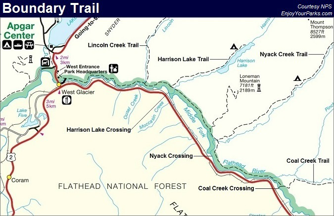
The Boundary Trail in Glacier National Park runs from the trailhead at West Glacier Montana all the way to the Coal Creek Trail Junction, which is about 16.3 miles one way. The Boundary Trail allows access to several remote Glacier Park hiking opportunities, such as Lincoln Creek Trail, Harrison Lake Trail, Loneman Lookout Trail, Nyack Creek Trail and Coal Creek Trail.
There are 3 designated river fords of the Middle Fork Flathead River that serve as significant short cuts to these Glacier Park hikes, which include the Harrison Lake Crossing, Nyack Crossing and Coal Creek Crossing. These crossings begin on the south side of the Middle Fork Flathead River along U.S. Highway 2, and connect with the Boundary Trail on the other side of the river (north). See the Boundary Creek Trail Map at the bottom of this page.


