Glacier Park

Our Favorite Businesses
Follow Us
On Social

Siyeh Pass
Includes Boulder Creek Valley, Baring Creek Valley, Preston Park, Sexton Glacier Overlook

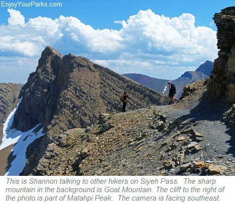
Shannon standing on Siyeh Pass with Mount Siyeh looming in the background.
Siyeh Pass
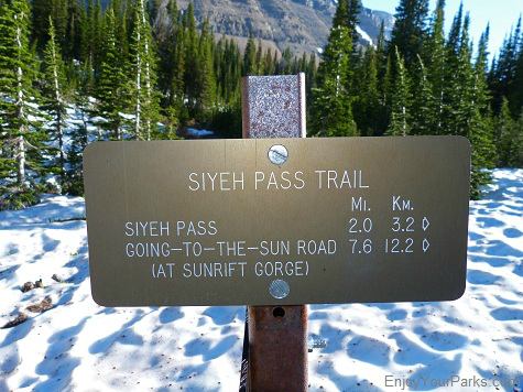
Trailhead: Siyeh Bend on the Going To The Sun Road
Distance: 4.7 miles (one way) from Siyeh Bend to Siyeh Pass
Distance: 10.3 miles (one way) from Siyeh Bend to Sunrift Gorge
Elevation Gain: 2,240 vertical feet
Elevation Loss: 3,440 vertical feet (If you end up at Sunrift Gorge)
 Siyeh Pass is one of our favorite hikes in Glacier National Park. The entire hike is extremely scenic, and the view from Siyeh Pass is spectacular. At 8,080 feet above sea level, Siyeh Pass is one of the highest in Glacier Park, which means that you'll have a fair amount of vertical elevation gain from the trailhead at Siyeh Bend. But because Siyeh Bend is on the Going To The Sun Road at about 5,800 feet, your total elevation gain at the pass is 2,240 vertical feet. This is still a lot of uphill hiking in only 4.7 miles, so you need to be in at least decent physical condition before attempting this popular hike to Siyeh Pass.
Because of the high elevation, a ton of snow accumulates on the back side of Siyeh Pass along the east face of Matahpi Peak and Going To The Sun Mountain, and it can linger well into late July and sometimes early August, depending on the year. So ask a ranger if the trail is safe to hike before you begin your day. If the backside of the trail is unsafe, then simply hike to Siyeh Pass, enjoy the incredible view, and head back the way you came instead of hiking down the Baring Creek Valley to Sun Rift Gorge.
Finding the Trailhead: Siyeh Bend

The Siyeh Bend on the Going To The Sun Road is where the trailhead is located for Siyeh Pass and Piegan Pass in Glacier National Park.
The hike to Siyeh Pass in Glacier National Park begins at Siyeh Bend along the Going To The Sun Road, about 3 miles east of Logan Pass. Located on the east side of the Going To The Sun Road, Siyeh Bend is between the Jackson Glacier Overlook and Logan Pass. Siyeh Bend is an extremely sharp turn in the Sun Road at Siyeh Creek, and the trailhead sign is easy to spot on the north side of the road (see photo above). There is also a shuttle stop located at Siyeh Bend.
The Hike to Siyeh Pass
From the trailhead, the trail follows the east bank of Siyeh Creek for only a few hundred yards, and then heads to the right into a deeply forested area of firs and spruces underneath Going To The Sun Mountain. In about 1.2 miles you will encounter the Piegan Pass Trail junction. GO LEFT to continue onward to Siyeh Pass.
This Glacier Park trail then heads straight north as it works its way around the west side of the great Going To The Sun Mountain through a fairly dense forest of firs spruces. The huge cliffs of this famous mountain loom above you to the right (east), and to your left (west) looms the amazing Piegan Mountain. As you head further north, you will get a great view of Piegan Glacier, which rests on the east face of this huge mountain. (See photo below)

Shannon hiking along the trail to Siyeh Pass in Glacier National Park with Piegan Mountain and Piegan Glacier rising above her to the west.
Siyeh Pass Trail Junction (Mile 2.7)
The trail continues north for about another 1.5 miles until you encounter the Siyeh Pass Trail junction. The trail to the left takes you to Piegan Pass, and the trail to the right takes you to Siyeh Pass (see photo below). As you take this trail to the right (the Siyeh Pass Trail), you will be led through an incredible subalpine area known as Preston Park. This gorgeous area is home to stunningly green meadows, beautiful fields of wildflowers and subalpine larch and stunted fir trees. Preston Park is an amazing place that you will thoroughly enjoy hiking through on your way to Siyeh Pass in Glacier National Park.

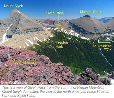
This is a view of the Siyeh Pass Trail from the summit of Piegan Mountain. The camera is facing east.
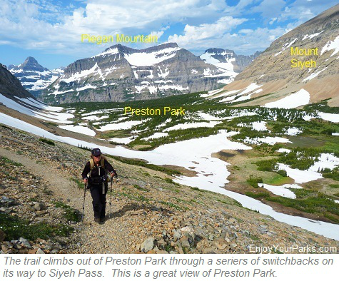
Preston Park

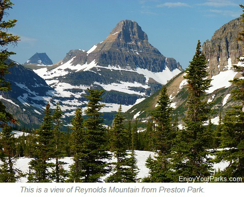
Shannon heading up towards Siyeh Pass after leaving Preston Park in Glacier National Park. The camera is facing straight west. Behind her are amazing views of Piegan Mountain, Piegan Glacier, and Reynolds Mountain (far to the left). As you can see, you will definitely encounter snow early in the season. This photo was taken on July 19th.
Preston Park in Glacier National Park is a gorgeous area of lush green fields, dwarf fir trees and subalpine larch. And during certain times of the summer, the wildflowers are amazing.
The photo to the right is a dramatic view of Reynolds Mountain from Preston Park. This view is behind you so don't forget to look back once in awhile!
As you hike through Preston Park, Mount Siyeh will tower over you to the north (left) and Matahpi Peak towers over you to the south (right). Mount Siyeh is one six peaks in Glacier National Park that is over 10,000 feet high.
Final Switchbacks
Once you've hiked through the amazing Preston Park in Glacier National Park, the trail to Siyeh Pass will begin to climb quite abruptly as you enter the higher altitude alpine environment.
You will encounter several switchbacks that help make this hike a little less strenuous. As you climb in elevation, the view to the west (behind you) becomes more and more dramatic. Therefore, don't forget to look back periodically so you can enjoy this spectacular view.
Once you reach the switchbacks just beyond Preston Park, you are very close to Siyeh Pass!
The wildflowers can be amazing along the Siyeh Pass Trail in Glacier National Park. This photo is looking back on Preston Park and Piegan Mountain. A portion of Mount Siyeh is visible on the right hand side of this photo. We are only about 0.3 miles from Siyeh Pass at this point.


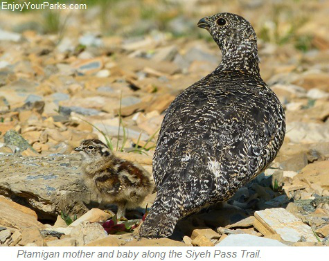
We had the pleasure of watching a Ptarmigan family in the wildflowers just before we reached Siyeh Pass in Glacier National Park. There was a mother and three little babies... this photo is one of those darling little chicks. You just never know what you're going to see while hiking in Glacier National Park!
As you gain elevation through the series of switchbacks along the Siyeh Pass Trail in Glacier National Park, you will get closer and closer to Siyeh Pass to the east. The terrain is now alpine, and the view is quite dramatic as you look back at Preston Park. Also, Mount Siyeh becomes more and more prominent as you continue the ascent.
Mount Siyeh is one of the six peaks over 10,000 feet in Glacier National Park (known as "The Big Six"), and this massive peak dominates the view to the north.
Beyond Mount Siyeh to the north is Cracker Lake and the Many Glacier Area, all of which is of course not visible from this vantage point because they're blocked by the massive south face of Mount Siyeh. (By the way, the North Face of Mount Siyeh is one of the highest walls in North America, being over 4,200 feet straight up!)
Mataphi Peak dominates the view to the south, that is until you reach Siyeh Pass in Glacier National Park. Siyeh Pass is located on the far east end of Matahpi Peak, which opens up the view to the south. The photo above was taken from the summit of Piegan Mountain, and it nicely illustrates how Mount Siyeh dominates the north and Matahpi Peak to the south, especially while hiking through Preston Park.
Siyeh Pass

This is the northward view from Siyeh Pass. The entire northern view is dominated by the gigantic Mount Siyeh, which is one of the six peaks in Glacier Natioinal Park that is over 10,000 feet high.
Once you reach Siyeh Pass (elevation 8,080 feet), the view really opens up to the east and to the south, and this change of scenery is very dramatic and jaw dropping.
As you look to the north, all you will see is the mighty Mount Siyeh and Cracker Peak to the east (left) side of Mount Siyeh. To the east, you will get a wonderful view of the remote Boulder Creek Valley.
To the south you will get a view of Little Chief Mountain, which rises above the south side of the Going To The Sun Road just south of Sunrift Gorge. The west view is completely blocked by Mataphi Peak because the trail is literally on the east slope of this great mountain.
By the way, we usually see several mountain goats in this area, so keep an eye open for them!

This is a view to the east from Siyeh Pass of the remote Boulder Creek Valley in Glacier National Park.
Beyond Siyeh Pass.... 5.6 miles to Sunrift Gorge

This is a view to the south as you keep hiking southward from Siyeh Pass along the Siyeh Pass Trail in Glacier National Park. The large mountain to the right is Going To The Sun Mountain, and the mountain in the middle of the photo is Little Chief Mountain. (The camera is facing straight south). The trail descends off this alpine meadow far below into the Baring Creek Valley and onto Sunrift Gorge on the Going To The Sun Road 5.6 miles south of Siyeh Pass.
Once you reach Siyeh Pass in Glacier National Park and enjoyed the incredible view, you have the choice of either going back the way you came and hike back to your vehicle parked at the Siyeh Bend on the Going To The Sun Road (4.7 miles), or you can keep going another 5.6 miles to Sunrift Gorge on the Sun Road. There you can catch a shuttle to get you back to your vehicle on Siyeh Bend.
If you choose to keep going, keep in mind that you will drop about 3,440 vertical feet. So those of you whose knees do not agree with a lot of downhill, you might want to go back the way you came. However.....
Baring Creek Valley

Did we mention that their might be some snow on this portion of the hike? This is a view to the south while standing on the Baring Creek Valley Headwall. At the time this photo was taken (July 19th) the Siyeh Pass Trail was closed just beyond where we were standing. Sunrift Gorge along the Going To The Sun Road is the final destination of this portion of the Siyeh Pass hike in Glacier National Park, but not on this particular day.
HOWEVER, If you're OK with a lot of downhill hiking, and you feel you will be able to make the last shuttle stop, then we highly recommend that you keep going.
PLEASE NOTE: Make sure that you know (from a ranger) that the trail is open before you attempt this portion of your Glacier Park hike on the Siyeh Pass Trail because the east slopes of Matahpi Peak and Going To The Sun Mountain get a tremendous amount of snow, and it can linger until late July (or even August) on certain years.
Important Suggestion:
If you are planning to hike all the way to Sunrift Gorge AND you know the trail is open underneath the east faces of Matahpi Peak and Going To The Sun Mountain, then we STRONGLY recommend that you park your car at Sunrift Gorge in the morning, then catch a shuttle to Siyeh Bend and then begin your hike to Siyeh Pass. That way you won't have to worry all day about catching the shuttle before they shut down for the evening. This is a really important tip that will make your hike to Siyeh Pass much more enjoyable.

This is a view from the summit of Matahpi Peak looking down on the Baring Creek Valley.
This portion of the Siyeh Pass Trail will take you down into the Baring Creek Valley, and the views are absolutely wonderful.
You will get a tremendous view of the east faces of Mataphi Peak and Going To The Sun Mountain, as well as Sexton Glacier.
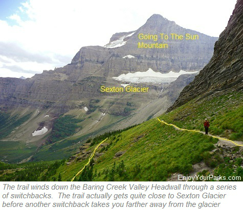
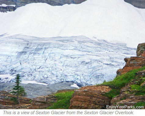
Sexton Glacier rests on the east face of Going To The Sun Mountain, and you can actually get quite close to this famous glacier as the trail meandors through many switchbacks as it works its way down the Baring Creek Valley Headwall. The closest point that the trail gets to Sexton Glacier is called the "Sexton Glacier Overlook".
As you continue to lose elevation as the Siyeh Pass Trail in Glacier National Park takes you further and further down the headwall of the Baring Creek Valley, the trail eventually straightens out and begins the long hike above Baring Creek all the way to Sunrift Gorge along the Going To The Sun Road. This portion of your Glacier Park hike is also very scenic, especially the view of the east faces of Matahpi Peak and Going To The Sun Mountain. Another nice treat along this trail is looking down at Baring Creek to your right. The water has cut away the rock in a very interesting way, creating amazing gorges and pools.

Shannon standing at the foot of Sexton Glacier near the Siyeh Pass Trail.
Sunrift Gorge
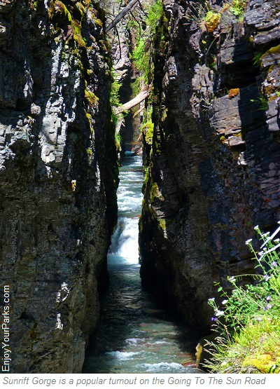
After descending over 3,400 vertical feet from Siyeh Pass in Glacier National Park, eventually the trail works its way along the west slope of Goat Mountain, following Baring Creek, until you reach Sunrift Gorge and the Going To The Sun Road. This completes your Glacier Park hike to Siyeh Pass, and you now must take a shuttle back to your vehicle that's parked at the Siyeh Bend.
Suggestion:
Again, if you know the trail beyond Siyeh Pass is open, and you want to hike from Siyeh Bend to Sunrift Gorge, then we STRONGLY recommend that in the morning, park your car at Sunrift Gorge, and then take a shuttle to Siyeh Bend and then begin your hike to Siyeh Pass. This will avoid having to get to Sunrift Gorge before the shuttles shut down for the day. This way you can enjoy your day and not be rushed or worried.
Also, be aware that the Baring Creek Valley is a popular grizzly bear hangout during the August berry season, so make sure you talk loud so you don't surprise any grizzlies, and of course always carry your bear spray and know how and when to use it.
The Glacier Park hike to Siyeh Pass is one of our favorite hikes in Glacier National Park, and once you take this amazing hike, you'll see why!

Sunrift Gorge parking area along the Going To The Sun Road in Glacier National Park.

Share This Page On Social:
